This book is a history of the Army Survey Regiment from its creation in 1932 as the Drafting Sub-Section of the Australian Survey Corps until the Regiment’s closure in 1996. In 1942, the then Land Headquarters Carto -graphic Company moved from Melbourne to Bendigo in central Victoria, where it evolved into the Army Survey Regiment. It would grow to become the largest mapping entity in the Southern Hemisphere.
(hardcover); RRP $60; Ursula Davidson Library call number Q503.2 LOVE 2003
The Survey Regiment had a unique operational peacetime role in that it was tasked with mapping northern Australia, Australia’s territories and other countries in the south-west Pacific. It produced maps for the Australian Army, aeronautical charts for the Royal Australian Air Force and printed hydrographic charts for the Royal Australian Navy.
At the start of World War II, the Australian Survey Corps had produced military topographical maps that covered only 1.3 per cent of Australia; another aspect of Australia’s reliance and misplaced confidence in Imperial defence between the wars. An emergency mapping scheme was set up, but maps of the vital areas could not be produced in time to meet a possible Japanese threat. So, a strategic mapping scheme was set up focused on the eastern coastal strip from Townsville to Port Augusta; the western strip from Geraldton to Albany; and some areas around Darwin and in Tasmania.
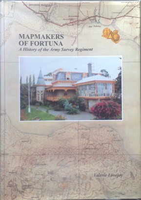
The Bendigo survey connection began in late 1941 when the officer commanding the Land Headquarters Cartographic Company, while enroute from Melbourne to Mildura where he anticipated finding ideal space and light for a major mapping installation, inspected a rambling mansion on 15 acres during an overnight stay in Bendigo. This was Fortuna which had been developed by George Lansell who had become wealthy in the 1850s gold mining era. His search ended immediately as he deemed Fortuna suitable for his needs.
Army cartographers occupied the Bendigo property from 1942 until 1996 when the Survey Regiment was merged back into the Royal Australian Engineers – from which it had been created in 1915. The Survey Regiment mostly survived the post-World War II reductions because the need for national mapping was well accepted. In 1951, the Commonwealth purchased Fortuna for 11,000 pounds ($22,000).
The Vietnam War returned the Survey Regiment to the Army’s mainstream. The Survey Regiment produced maps for our forces in Vietnam at short notice and with remarkable speed – well before electronic data transmission or even facsimile machines provided instant despatch. The Survey Troop in theatre established survey control in the operational area as a basis for theatre grid, prepared overprint amendments, produced sketch maps and map enlargements, held and distributed maps for the Australian Task Force and advised on survey matters. The Bendigo facility produced enlarged maps at short notice. As the only Regular Army unit in northern Victoria, it also was required to report casualties to soldiers’ families and conduct some military funerals. By 1971, anti-Vietnam sentiment caused soldiers to no longer wear uniforms in public.
Surveying techniques and products are vital to all navigation, personnel safety, the co-ordination of fire power and predicted fire. The current plethora of global positioning system (GPS) and smart-phone applications which aid navigation, has made perfect survey all but taken for granted. But the pioneers of survey deserve enduring respect. Moreover, their methods and standards will need to be replicated should cyber threats or human errors related to GPS applications be realised. Just as many mariners retain charts, sextants and associated skills, so land-based warriors should not lose their map reading and compass acuities.
There are other studies of army survey from 1915 until 1996. This work, however, provides a formal record of the Army Survey Regiment’s contribution to the mapping of Australia, a clear discussion of changing technology, and a social history of regimental life and the personalities involved. The association of army surveyors with Bendigo continues – a good reason to reflect on the long-term costs of the Army’s current stance on public engagement.
There are helpful photos; useful appendices, including one on printing technology; and an impressive bibliography. This work deserves attention by students of cartography, surveying and Australian military history – cartography because the Land Headquarters Cartographic Company became the largest map making entity in the Southern Hemisphere during World War II.
Our thanks are especially due to Colonel Don Swiney MBE (Ret’d). A former commanding officer of the 1st Survey Regiment and later Director of Survey, he donated the volume reviewed herein to the Ursula Davidson Library.
This study is well and respectfully written by a local historian, with the aid of Survey Corps veterans and is informed by prodigious research. I recommend it to all interested in the history of Australian map-making, especially military map-making, in the 20th century.
Reviewed for RUSI by Ken Broadhead
Contact Royal United Services Institute about this article.